Roof Maintenance in General
Waterproofing problems manifest themselves in two ways: Leakage and entrained moisture contamination. Leakage is pretty simple, although the leak inside the building rarely directly relates to the exact spot on the roof, since the water flows down the slope of the roof to a spot that is not sealed and into the building at that point. Most leaks occur where the waterproofing is sealed or where there is a penetration of the roof. Since most types of roof systems absorb some amount of water, it is harder to find the exact spot of water contamination in the insulation because it may not leak into the building until it has absorbed all the water it can hold.
There are three types of surveys that are used to find water in a roof. Nuclear gauges-which count neutrons, capacitance meters-which measure resistance, and infrared-which measures heat. Both nuclear gauges and capacitance meters are used to take spot readings on a 5’ X 5’, 10′ X 10′ or 20′ X 20′ grid on the roof. These measurements are used to extrapolate where the water is from the readings obtained from the gauges. These surveys are very labor-intensive and therefore expensive. They are good for types of roofs that do not gain or lose much solar energy and therefore, do not lend themselves to infrared.
Roof Infrared Basics
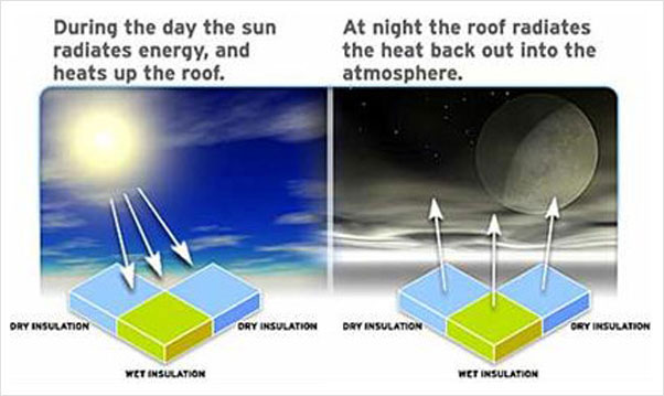
During the day, the sun radiates energy onto the roof and into the roof substrate, and then at night, the roof radiates the heat back into outer space. This is called radiational cooling. Areas of the roof that are of a higher mass (wet) retain this heat longer than that of the lower mass (dry) areas. Infrared imagers can detect this heat and “see” the warmer, higher mass areas, during the “window” of uneven heat dissipation.
Why Aerial Infrared
Performing infrared roof moisture surveys while standing on the roof is not the best method because imagery from a walk-on survey is not as useful as aerial imagery. The same laws of physics apply to both aerial IR and on-roof IR. A dry roof, low winds and no rain are needed on the night of the survey. However, the “window” when the roof is radiating heat differently from wet and dry areas is longer with aerial infrared because slight nuances of temperatures over large areas are recognizable. A high angle of view and high resolution are needed to produce usable imagery. We use large-format infrared cameras, which have at least 512 x 512 staring array detectors (262,144 pixels). From an altitude of 1,200 – 1,500 feet above the roof with over a quarter of a million pixels, the ground resolution element is about six inches square.
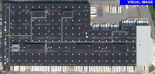
Visual photographs are taken earlier in the day or the next day. Both visual and infrared images are used to do the analysis by overlaying the AutoCAD drawing of the roof ‘over’ the digitized photographs and thermographs. The drawings are created indicating areas of suspected moisture contamination. The result is a report where visual, infrared and AutoCAD components (printed and video) are well matched and lined-up.
FIXED-WING AERIAL INFRARED IMAGING PROVIDES MANY ADVANTAGES OVER ON-ROOF INFRARED IMAGING:
- Fixed-wing aerial infrared imaging provides many advantages over on-roof infrared imaging:
- High-angle, straight down infrared images lessen reflection problems. High-resolution images capture large areas at once, making report writing easier and less expensive to produce.
- Plan view allows for infrared images, visual images and AutoCAD drawings to be reconciled closely. As a result, the report is clear, concise and easy to understand (see Figure 4,5,6).
- Plan view imaging allows accurate marking of areas of suspect roof moisture contamination.
- The printed AutoCAD drawings can be used on the roof to paint areas of moisture contamination directly on the roof (after verification), if desired.
- The trending of roof moisture becomes possible.
AERIAL IR ALLOWS THE BUILDING OWNER TO BUY ONLY THE REPORT HE NEEDS AT THAT TIME.
- Further processing can be done on roof areas of specific concern. The report components are as follows in order by cost:
- Unedited videotape. The raw videotape of the infrared flight over the building.
- Edited videotape. An edited videotape can be made from the original digital video.
- Printed thermographs. Printed infrared thermographs of each roof section can be captured and printed in high-resolution.
- Aerial photographs. Printed digital and/or conventional photographs of the roof (straight down) and site (beauty shots of the building and property) can be printed. Note: A straight down photograph of a roof section aids significantly in the infrared analysis, showing stains, equipment and roof boundaries, etc.
- AutoCAD drawings. Accurate AutoCAD drawings can be made, then printed and saved to disk
- Digital and printed report. A complete quantitative aerial infrared roof moisture survey report would include all of the above, printed in high resolution and saved to a CD.
The biggest advantage of aerial infrared is on roofs that are the most difficult to image from any distance or angle. Roofs that, for instance, have a lot of ballast, are covered with reflective coatings or for whatever reason are impossible to image from the roof. With high-resolution, plan view aerial imagery, slight nuances of temperature can be seen from far enough away to actually see the pattern of heat and make a determination of where the problems are.