AITScan FindIR™ Services
Roof Moisture FindIR™
Performing infrared roof moisture surveys while standing on the roof is not the best method because imagery from a walk-on survey is not as useful as aerial imagery. The same laws of physics apply to both aerial IR and on-roof IR.
Steam Leak FindIR™
Checking the boilers and the lines in the steam tunnels are jobs done on the ground, but the distribution and condensate return lines that are direct-buried are best surveyed from the air by our aerial infrared thermography experts.
Pollution FindIR™
Stormwater collection systems are engineered to discharge into surface waters to efficiently drain selected areas. All too often these systems convey pollutants from illicit connections, degraded sanitary sewers and other sources.
Animal FindIR™
Counting and identifying a variety of captive animal types have given us high confidence in identifying deer in their normal forest, rural and suburban habitats.
LandFillFire FindIR™
The U.S. Forest Service uses aerial infrared imaging to monitor forest fires. This information can be sent immediately to those in charge of controlling fire lines.
HTHW Leak FindIR™
With high-resolution, plan view aerial imagery, slight nuances of temperature can be seen from far enough away to actually see the pattern of heat and where the problems are.
AITScan Is The #1 Nationwide
Aerial Infrared Thermography Service
HIGHEST QUALITY REPORTS
Reports are created with high-angle, straight down (NADIR) infrared images, which reduce reflections and capture large areas at once, making the imagery easier to analyze and the report less expensive to produce.
COMBINATION OF IMAGE TYPES
Since images are captured straight-down or ‘plan view’, the report is clear, concise and easy to understand because infrared images, visual images and AutoCAD® drawings are reconciled.
DECADES OF EXPERIENCE
We have performed numerous qualitative infrared thermographic surveys of steam systems for universities, cities and industrial clients nationwide. We brought together all the components that truly make us the state-of-the-art in the field of infrared thermography and our deliverable product is the best on the market today. We use high-resolution infrared imagers, digital recording equipment, techniques that have been refined over the years and the attitude that we are going to obtain the best imagery possible and produce a professional report in a timely manner.
SURPRISINGLY AFFORDABLE
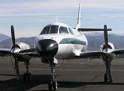
Fixed-wing aircraft allow AIT a cost-effective platform to obtain high quality infrared imagery, passing savings on to you!
How Our FindIR™ Services Can Help You Today:
THERMAL MAPPING
Problem areas are generally quite evident, having brighter white IR signatures that exceed the norm. Steam line faults normally appear as an overheated line or as a large hotspot in the form of a bulge or balloon along the line.
ROOF IMAGERY
Areas of roof moisture contamination often manifest themselves as warmer (lighter colored) areas that may be nebulous in shape and sometimes mottled in appearance, although they are commonly found in linear or puddle-like shapes.
WATERWAY IMAGERY
Leaking sewage collector lines, storm water drain discharges and illegal taps into storm water drainage lines can often be identified by their thermal infrared signatures during certain times of the year. As these sources of pollution leak, they can be pinpointed accurately from the air.
PUBLISHED RESOURCES
We have a large collection of published papers about aerial infrared thermography that are available for you to download. These articles are highly recognized across the infrared thermography industry, and will help you learn more about what our services can offer.
Get in Touch
A Division of Stockton Infrared Thermographic Services, Inc.
8472 Adams Farm Road
Randleman, NC 27317
